|
s.no
|
Name
|
Year of summit
|
Route
|
|
1.
|
Ashraf
Aman
|
1977
|
Abruzzi Ridge
|
|
2.
|
Nazir
Sabir
|
1981
|
West
side
|
|
3.
|
Rajab
Shah
|
1995
|
Abruzzi Ridge
|
|
4.
|
Meherban
Shah
|
1995
|
Abruzzi Ridge
|
|
5.
|
Hassan
Sadpara
|
2004
|
Abruzzi Ridge
|
|
6.
|
Nisar
Hussain Sadpara
|
2004
|
Abruzzi Ridge
|
|
7.
|
Shaheen
Beg
|
2004
|
Abruzzi Ridge
|
|
8.
|
Muhammad
|
2004
|
Abruzzi Ridge
|
|
9.
|
Meherban
Karim
|
2008
|
Abruzzi Ridge
|

A: West Ridge; B: West Face; C: Southwest Pillar;
D: South Face; E: South-southeast Spur; F: Abruzzi Spur

located in the regions of Gilgit–Baltistan (Pakistan), Ladakh (India), and Xinjiang region (China). A subrange of the Hindu Kush Himalayan Range, it is one of the Greater Ranges of Asia. The Karakoram is home to the highest concentration of peaks over 8000m in height to be found anywhere on earth,including K2, the second highest peak in the world 8,611 m (28,251 ft).
The range is about 500 km (311 mi) in length, and is the most heavily glaciated part of the world outside the polar regions. The Siachen Glacier at 76 kilometres (47 mi) and the Biafo Glacier at 63 kilometres (39 mi) rank as the world's second and third longest glaciers outside the polar regions.
The Karakoram is bounded on the northeast by the edge of the Tibetan Plateau, and on the north by the Pamir Mountains. The southern boundary of the Karakoram is formed, west to east, by the Gilgit, Indus, and Shyok Rivers, which separate the range from the northwestern end of the Himalaya range proper as these rivers converge southwestward towards the plains of Pakistan.
Mountains in Gilgit Baltistan

Pakistan is home to 108 peaks above 7,000 metres, and probably as many peaks above 6,000 m. There is no count of the peaks above 5,000 and 4,000 m. Five of the 14 highest independent peaks in the world (the eight-thousanders) are in Pakistan (four of which lie in the surroundings of Concordia; the confluence of Baltoro Glacier and Godwin Austen Glacier). Most of the highest peaks in Pakistan lie in the Karakoram mountain range (which lies almost entirely in the Gilgit–Baltistan region of Pakistan, and is considered to be a part of the greater Himalayan range) but some peaks above 7,000 m are included in the Himalayan and Hindu Kush ranges. Pakistan is home to the second highest mountain in the world, K2.
Karakorum View

Baltistan is home to more than 20 peaks of over 20,000 feet (6,100 m), including K2, the second highest mountain on Earth. Other well known peaks include Masherbrum (also known as K1), Broad Peak, Hidden Peak, Gasherbrum II,Gasherbrum IV, and Chogolisa, situated in Khaplu Valley. The following peaks have so far been scaled by various expedition:
| Name of Peak | Photos | Height | Date of Conquest | Location |
|---|---|---|---|---|
| 1.K-2 |  | (28,250Ft) | 31/7/1954 | Shigar District |
| 2. Gasherbrum I |  | (26,360Ft) | 7/7/1956 | Ghanche District |
| 3. Broad Peak |  | (26,550) | 9/6/1957 | Ghanche District |
| 4. Muztagh Tower |  | (23,800Ft) | 6/8/1956 | Ghanche District |
| 5. Gasherbrum II | | (26,120Ft) | 4/7/1958 | Ghanche District |
| 6. Hidden Peak |  | (26,470Ft) | 4/7/1957 | Ghanche District |
| 7. Khunyang Chhish |  | (25,761 Ft) | 4/7/1971 | Skardu District |
| 8. Masherbrum |  | (25,659 ft) | 4/8/1960 | Ghanche District |
| 9. Saltoro Kangri |  | (25,400Ft) | 4/6/1962 | Ghanche District |
| 10. Chogolisa |  | (25,148 Ft) | 4/8/1963 | Ghanche District |
K-2

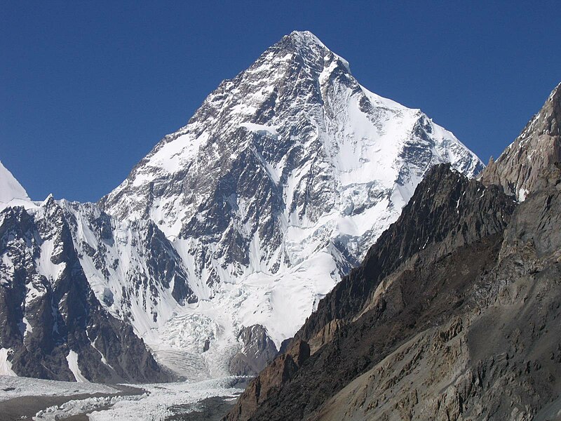
K2, also known as Chhogori/ (in Balti means Big Peak), is the second-highest mountain on Earth after Mount Everest. It is located on the border between Baltistan, in the Gilgit–Baltistan region of northern Pakistan, and the Taxkorgan Tajik Autonomous County of Xinjiang, China. With a peak elevation of 8,611 m (28,251 feet), K2 is the highest point of the Karakoram Range and the highest point in Pakistan.
K2 is known as the Savage Mountain due to the extreme difficulty of ascent and the second-highest fatality rate among the eight thousanders. One in every four people who have attempted the summit have died trying. It is more difficult and hazardous to reach the peak of K2 from the Chinese side; thus, it is usually climbed from the Pakistani side. Unlike Annapurna, the mountain with the highest fatality-to-summit rate (246 summits, 55 deaths), K2 has never been climbed during wintertime.\

The name K2 is derived from the notation used by the Great Trigonometric Survey. Thomas Montgomerie made the first survey of the Karakoram from Mount Haramukh, some 210 km (130 miles) to the south, and sketched the two most prominent peaks, labeling them K1 and K2.
The policy of the Great Trigonometric Survey was to use local names for mountains wherever possible and K1 was found to be known locally as Masherbrum. K2, however, appeared not to have acquired a local name, possibly due to its remoteness. The mountain is not visible from Askole, the last village to the south, or from the nearest habitation to the north, and is only fleetingly glimpsed from the end of the Baltoro Glacier, beyond which few local people would have ventured.The name Chogori, derived from two Balti words, chhogo ("big") and ri ("mountain") (شاہگوری) has been suggested as a local name, but evidence for its widespread use is scant. It may have been a compound name invented by Western explorers or simply a bemused reply to the question "What's that called?" It does, however, form the basis for the name Qogir (simplified Chinese: 乔戈里峰; traditional Chinese: 喬戈里峰; pinyin: Qiáogēlǐ Fēng) by which Chinese authorities officially refer to the peak. Other local names have been suggested including Lamba Pahar ("Tall Mountain" in Urdu) and Dapsang, but are not widely used.
Lacking a local name, the name Mount Godwin-Austen was suggested, in honor of Henry Godwin-Austen, an early explorer of the area, and while the name was rejected by the Royal Geographical Society[8] it was used on several maps, and continues to be used occasionally.
The surveyor's mark, K2, therefore continues to be the name by which the mountain is commonly known. It is now also used in the Balti language, rendered asKechu or Ketu (Urdu: کے ٹو). The Italian climber Fosco Maraini argued in his account of the ascent of Gasherbrum IV that while the name of K2 owes its origin to chance, its clipped, impersonal nature is highly appropriate for so remote and challenging a mountain. He concluded that it was .
Climbing history

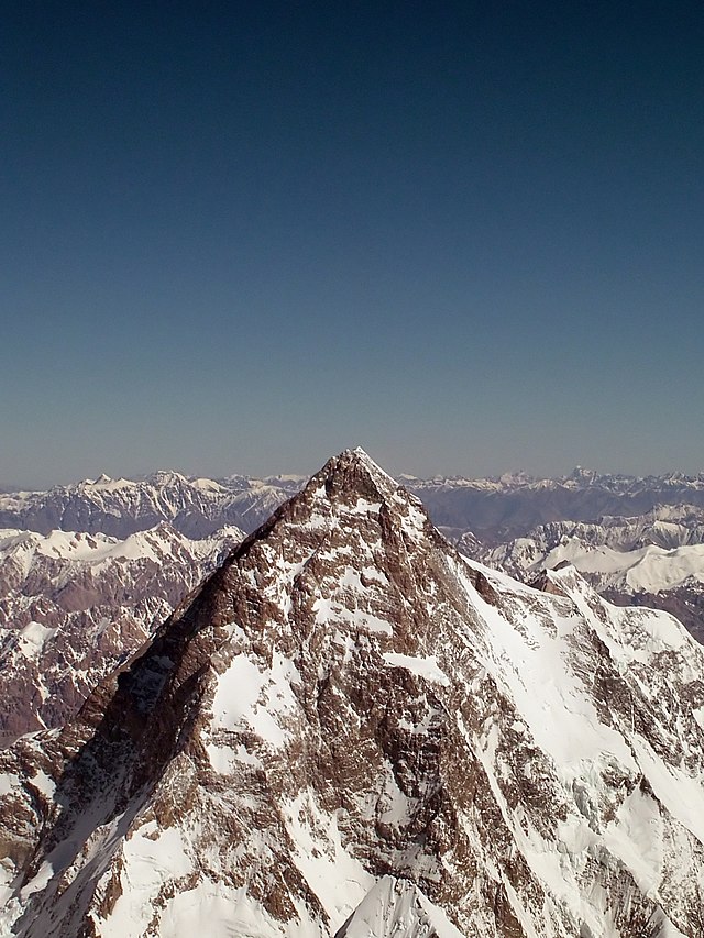
The west face of K2 taken from the Savoia Glacier on the 1909 expedition
Early attempts
The mountain was first surveyed by a European survey team in 1856. Thomas Montgomerie was the member of the team who designated it "K2" for being the second peak of the Karakoram range. The other peaks were originally named K1, K3, K4 and K5, but were eventually enarmed Masherbrum, Gasherbrum IV, Gasherbrum II and Gasherbrum I respectively. In 1892, Martin Conway led a British expedition that reached "Concordia" on the Baltoro Glacier.
The first serious attempt to climb K2 was undertaken in 1902 by Oscar Eckenstein, Aleister Crowley, Jules Jacot-Guillarmod, Heinrich Pfannl, Victor Wessely and Guy Knowles via the Northeast Ridge. In the early 1900s, modern transportation did not exist: It took "fourteen days just to reach the foot of the mountain". After five serious and costly attempts, the team reached 6,525 metres (21,407 ft)—although considering the difficulty of the challenge, and the lack of modern climbing equipment or weatherproof fabrics, Crowley's statement that "neither man nor beast was injured" highlights the pioneering spirit and bravery of the attempt. The failures were also attributed to sickness (Crowley was suffering the residual effects of malaria), a combination of questionable physical training, personality conflicts, and poor weather conditions—of 68 days spent on K2 (at the time, the record for the longest time spent at such an altitude) only eight provided clear weather.
The next expedition to K2, in 1909, led by Prince Luigi Amedeo, Duke of the Abruzzi, reached an elevation of around 6,250 metres (20,510 ft) on the South East Spur, now known as the Abruzzi Spur (or Abruzzi Ridge). This would eventually become part of the standard route, but was abandoned at the time due to its steepness and difficulty. After trying and failing to find a feasible alternative route on the West Ridge or the North East Ridge, the Duke declared that K2 would never be climbed, and the team switched its attention to Chogolisa, where the Duke came within 150 metres (490 ft) of the summit before being driven back by a storm.
The next attempt on K2 was not made until 1938, when an American expedition led by Charles Houston made a reconnaissance of the mountain. They concluded that the Abruzzi Spur was the most practical route, and reached a height of around 8,000 meters (26,000 ft) before turning back due to diminishing supplies and the threat of bad weather. The following year an expedition led by Fritz Wiessner came within 200 metres (660 ft) of the summit, but ended in disaster when Dudley Wolfe, Pasang Kikuli, Pasang Kitar and Pintso disappeared high on the mountain.
Charles Houston returned to K2 to lead the 1953 American expedition. The expedition failed due to a storm that pinned the team down for ten days at 7,800 metres (25,590 ft), during which time Art Gilkey became critically ill. A desperate retreat followed, during which Pete Schoening saved almost the entire team during a mass fall, and Gilkey was killed, either in an avalanche or in a deliberate attempt to avoid burdening his companions. In spite of the failure and tragedy, the courage shown by the team has given the expedition iconic status in mountaineering history.
Success and repeats
The third ascent of K2 was in 1978, via a new route, the long and corniced Northeast Ridge. The top of the route traversed left across the East Face to avoid a vertical headwall and joined the uppermost part of the Abruzzi route. This ascent was made by an American team, led by James Whittaker; the summit party was Louis Reichardt, Jim Wickwire, John Roskelley, and Rick Ridgeway. 
Wickwire endured an overnight bivouac about 150 metres (490 ft) below the summit, one of the highest bivouacs in history. This ascent was emotional for the American team, as they saw themselves as completing a task that had been begun by the 1938 team forty years earlier.On 9 August 1977, 23 years after the Italian expedition, Ichiro Yoshizawa led the second successful ascent, with Ashraf Aman as the first native Pakistani climber. The Japanese expedition took the Abruzzi Spur, and used more than 1,500 porters.
Wickwire endured an overnight bivouac about 150 metres (490 ft) below the summit, one of the highest bivouacs in history. This ascent was emotional for the American team, as they saw themselves as completing a task that had been begun by the 1938 team forty years earlier.On 9 August 1977, 23 years after the Italian expedition, Ichiro Yoshizawa led the second successful ascent, with Ashraf Aman as the first native Pakistani climber. The Japanese expedition took the Abruzzi Spur, and used more than 1,500 porters.
Another notable Japanese ascent was that of the difficult North Ridge on the Chinese side of the peak in 1982. A team from the Mountaineering Association of Japan led by Isao Shinkai and Masatsugo Konishi put three members, Naoe Sakashita, Hiroshi Yoshino, and Yukihiro Yanagisawa, on the summit on 14 August. However Yanagisawa fell and died on the descent. Four other members of the team achieved the summit the next day.
The first climber to reach the summit of K2 twice was Czech climber Josef Rakoncaj. Rakoncaj was a member of the 1983 Italian expedition led by Francesco Santon, which made the second successful ascent of the North Ridge (31 July 1983). Three years later, on 5 July 1986, he reached the summit via the Abruzzi Spur (double with Broad Peak West Face solo) as a member of Agostino da Polenza's international expedition.
The first woman to summit K2 former Pole Wanda Rutkiewicz - 23 June 1986.
In 1986, two Polish expedition paved two new hard road - Magic Line and Polish Line. This second has not yet been repeated.
In 2004 the Spanish climber Carlos Soria Fontán became the oldest person ever to summit K2, at the age of 65.
 The peak has now been climbed by almost all of its ridges. Although the summit of Everest is at a higher altitude, K2 is a much more difficult and dangerous climb, due in part to its more inclement weather and comparatively greater height from base to peak. The mountain is believed by many to be the world's most difficult and dangerous climb, hence its nickname "the Savage Mountain". It, and the surrounding peaks, have claimed more lives than any others. As of July 2010, only 302 people have completed the ascent, compared with over 2,700 who have ascended Everest. At least 80 (as of September 2010) people have died attempting the climb. Thirteen climbers from several expeditions died in the 1986 K2 Disaster, August 13, 1995 killed six mountaineers, eleven climbers died in the 2008 K2 disaster.
Recent attempts
- 2008
- On 1 August 2008, a group of climbers went missing after a large piece of ice fell during an avalanche taking out the fixed ropes on part of the route; four climbers were rescued, but 11, including Gerard McDonnell, the first Irish person to reach the summit, were confirmed dead.
- 2009
- Despite several attempts, nobody won the summit.
- 2010
- On 6 August 2010, Fredrik Ericsson, who intended to ski from the summit, joined Gerlinde Kaltenbrunner on the way to the summit of K2. Ericsson fell 1,000 metres (3,300 ft) and was killed. Kaltenbrunner aborted her summit attempt.
Despite several attempts, nobody won the summit.
- 2011
- On August 23, 2011, a team of four climbers reached the summit of K2 from the North side. Gerlinde Kaltenbrunner became first woman to complete all 14eight-thousanders without supplemental oxygen. Kazakhs Maxut Zhumayev, and Vassiliy Pivtsov completed their eight-thousanders quest. The fourth team member was Dariusz Załuski from Poland
- 2012
- The year started with a vigorous Russian team aiming for a first winter ascent. The expedition ended on with the demise of Vitaly Gorelik due to frostbite and pneumonia. The Russian team cancelled the ascent. In the summer season, K2 saw a record crowd standing on its summit—28 climbers in a single day—bringing the total for the year to 30.
- 2013
- On 28 July 2013, two New Zealanders, Marty Schmidt and his son Denali, died after an avalanche destroyed their camp. A guide had reached the camp they were at, but said they were nowhere to be seen and the campsite tent showed signs of having been hit by an avalanche. British climber Adrian Hayes, who was with the group later posted on his Facebook page that the campsite had been wiped out.
- 2014
- On 26 July 2014, the first team of Pakistani climbers scaled K2. There are six Pakistani and three Italian climbers in the expedition, called K2 60 Years Later, according to BBC. Before, it was summited by individual Pakistanis as part of international expeditions.
Climbing routes and difficulties
There are a number of routes on K2, of somewhat different character, but they all share some key difficulties. First, is the extreme high altitude and resulting lack of oxygen: there is only one-third as much oxygen available to a climber on the summit of K2 as there is at sea level. Second is the propensity of the mountain to experience extreme storms of several days' duration, which have resulted in many of the deaths on the peak. Third is the steep, exposed, and committing nature of all routes on the mountain, which makes retreat more difficult, especially during a storm. Despite many attempts there have been no successful winter ascents. All major climbing routes lie on the Pakistani side, which is also where base camp is located.
The major routes to have been climbed on the south side of the mountain.
A: West Ridge;
B: West Face;
C: Southwest Pillar;
D: South Face;
E: South-southeast Spur;
F: Abruzzi Spur
No comments:
Post a Comment